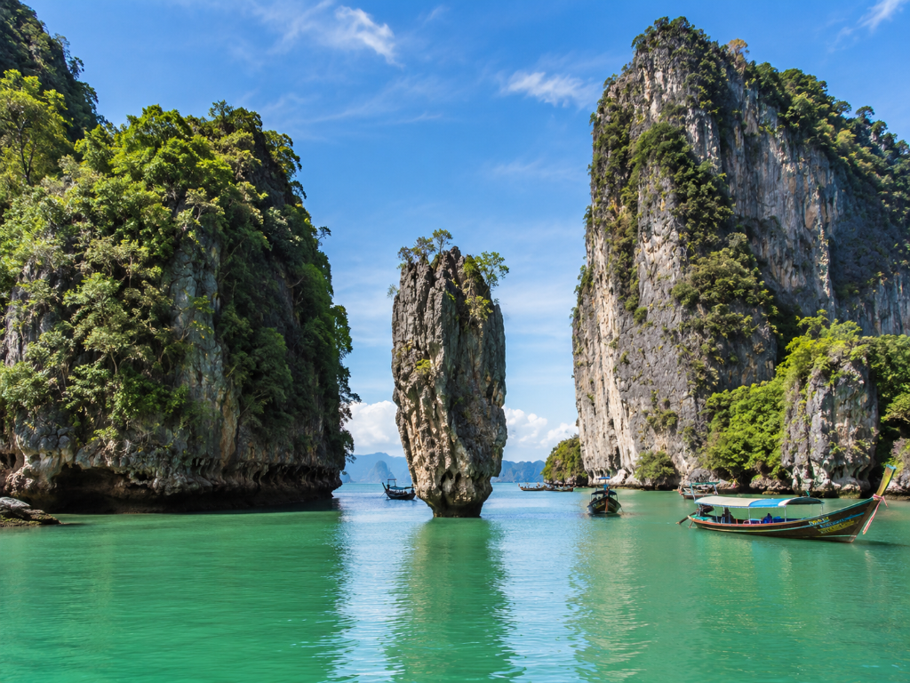
James Bond Island: Into the Stone Labyrinth of Phang Nga Bay
· 13 min read · Destination Guide
The route to James Bond Island begins among mangroves, fishing piers and broad channels the colour of tarnished jade. Blue barrels are stacked beneath corrugated roofs. Longtails leave narrow wakes between the mudbanks, while egrets stand among exposed roots, watching the boats pass with the grave concentration of sentries.
Beyond the villages, limestone begins to interrupt the sky. The first formations are distant and indistinct. Then the boat enters among them, and their scale becomes difficult to judge. Cliffs rise directly from the water, streaked with iron, soot and pale mineral deposits. Vegetation grips the upper ledges in unruly masses. Whole trees grow sideways from cracks in the rock. Channels appear only when the captain turns towards them, revealing passages that had seemed sealed moments earlier.
James Bond Island is the nominal destination. The real experience is an expedition through the flooded terrain surrounding it.
The boat travels north through a geography that refuses to remain legible. A broad island narrows into a blade when seen from the side. Two separate cliffs align and become a single wall. A solid headland reveals an opening at its base, dark enough to resemble a doorway cut into the mountain.
The captain slows where the channel contracts. Engine noise ricochets between the cliffs, returning in low, distorted waves. The air cools inside their shadow. Mangroves crowd the edges wherever mud has accumulated, their roots twisting above the water like exposed wiring.
At low tide, the banks become busy with small movements. Mudskippers spring across the surface. Crabs vanish into holes. Monkeys sometimes appear among the lower branches, watching from beyond reach. A kingfisher flashes between the trees, blue and copper for less than a second.
The water remains almost flat, but the bay is not still. Tidal current curls around the limestone bases. Longtails appear abruptly from hidden channels, bows painted in scarlet, yellow and cobalt, then disappear behind another wall of stone. There is a growing sense that the route is being discovered rather than followed.
Ko Tapu does not dominate the bay from a distance. It waits behind the larger karsts, concealed until the final approach to Khao Phing Kan. Then the rock appears in full.
Its base is unnervingly narrow, darkened by tide and marine growth. Above it, the column expands into an irregular crown of weathered limestone and vegetation. It resembles a fragment of a much larger formation that has somehow remained upright after everything around it collapsed.
Seen from the beach, Ko Tapu is framed by layers of cliff, open water and passing boats. Its proportions shift continually. A longtail crossing behind it makes the rock seem immense. A towering karst farther away reduces it to a slender geological accident.
The surface bears the violence of its formation. Vertical channels run through ochre and grey stone. Black staining marks the lower section. Ferns grow from ledges that appear incapable of holding soil. The rock is famous because it is strange, not because it is conventionally beautiful.
There are crowds, particularly near midday. Boats arrive in quick succession, and the small viewing area fills with visitors trying to secure the familiar angle. Yet the congestion does not make the formation less peculiar. Ko Tapu remains slightly unsettling, balanced above the water in a shape that looks temporary despite having endured for millennia. It deserves to be seen quickly and then placed back within the larger mystery of the bay.
Khao Phing Kan is more physically imposing than the offshore landmark that made it famous. Two colossal limestone slabs tilt towards one another, leaving a narrow corridor between them. Walking into the gap feels like entering the fault line of a mountain.
The temperature drops immediately. Sunlight disappears from the upper walls, leaving the stone in shades of pewter, rust and damp green. Water marks trace horizontal lines across the rock. Roots descend from above, probing cracks in search of moisture.
The surfaces are rough and deeply fissured. Some areas flake beneath the fingers; others have been polished by countless hands. Voices return from the stone in altered form, louder and lower than expected. Look upward and the narrow strip of sky seems improbably far away.
Outside the passage, sunlight lands with force. The beach is crowded with arriving boats, vendors and people moving between the shore and the Ko Tapu viewpoint. Inside, the leaning slabs contain their own climate: cool air, mineral damp and the faint smell of wet earth. The transition lasts only a few steps, but it is one of the island's most visceral details.
The exploration deepens when the main boat is exchanged for a canoe. The guide steadies the smaller craft while passengers lower themselves close to the water. Bags are placed between knees. The paddle dips once, and the canoe leaves the bright open channel for the base of a cliff.
At first, the cave entrance seems impassable. It is little more than a horizontal cut in the limestone. The ceiling slopes down towards the water until there appears to be no room for a person, much less a canoe. The guide waits for the small surge to pass, then signals everyone to lean back.
Stone slides overhead inches from the face. The light behind narrows. Heat falls away. The paddle is laid flat while the guide pulls the canoe forward with one hand against the rock.
Inside, water amplifies every sound. A drip from the ceiling lands with a hollow knock. The canoe nudges the wall. Breathing becomes conspicuously loud. Oyster shells cover the lower stone in hard clusters, and tiny crabs retreat into the cracks as the hull passes.
The tunnel bends, removing the entrance from view. For several seconds there is only black water, the beam of a torch and the uneven underside of the mountain overhead. Stalactites descend like blunt teeth. Pale mineral deposits shine briefly, then disappear behind the canoe.
A wash of green light appears ahead. The roof lifts. The rock opens. The canoe slides into a lagoon enclosed entirely within the karst.
The hidden lagoon is neither cave nor open bay. It is a chamber without a roof. Limestone walls rise on every side, their upper edges framing an irregular opening of sky. Vines drop in long cords from the cliffs. Mangroves occupy the mud at the centre, their roots submerged where the tide has risen and exposed where it has withdrawn.
The canoe moves without engine noise. A macaque shifts among the branches high above. Leaves fall and touch the water without sound. Insects gather beneath the vegetation. Somewhere inside the rock, droplets continue their steady descent.
The air is warm again, though cooler than outside. It smells of wet leaves, mud and limestone. Sunlight reaches only part of the enclosure, illuminating one wall while the opposite side remains in deep green shadow.
The lagoon feels inaccessible because, for much of the day, it is. At high tide, the entrance tunnel may fill too close to the ceiling. At very low tide, mud and exposed roots alter the route. The canoe enters during a narrow tidal permission, and the awareness of that limit gives the place its tension.
There is no grand viewpoint inside the hong. The experience is bodily: lying flat beneath the entrance, feeling the cave roof pass overhead, hearing darkness before seeing it, then emerging inside a mountain.
Back aboard the larger vessel, the route continues through narrower waterways. The cliffs no longer stand at a picturesque distance. They press close to the boat, revealing surfaces overlooked from open water. Fossilised shell patterns appear in pale stone. Rust-coloured streaks run from high crevices. Ferns cluster around seepage lines where moisture escapes from the rock.
Mangrove branches extend into the channel. Their leaves are waxy and salt-bright. At lower water, the roots form impenetrable cages above the mud. At higher water, only their upper curves remain visible, giving the illusion that the forest grows directly from the sea.
The captain reads the channel through signs invisible to passengers: the direction of floating leaves, the colour over shallow mud, the wake of another boat disappearing around a bend. A longtail approaches from the opposite direction. Both captains reduce speed. The vessels pass close enough to exchange a few words in Thai, then accelerate again once the channel widens.
This is where Phang Nga Bay feels most exploratory. There is no distant horizon to orient the journey, only rock, water and successive decisions.
Ko Panyee emerges from behind a karst as a dense horizontal settlement pressed against a vertical cliff. From the water, the village appears structurally impossible. Hundreds of roofs extend above the bay, supported by concrete and timber stilts. Walkways connect houses, restaurants, shops, a school and a mosque. Fishing boats occupy the lower edges while the limestone rises behind everything in a sheer, forested wall.
The green dome of the mosque provides the first point of orientation. Closer to shore, the village resolves into domestic detail. Shirts and school uniforms dry beneath awnings. Buckets hang from railings. Cats sleep on sun-warmed boards. Satellite dishes tilt above timber houses. Underneath, tidewater moves through the stilts carrying scraps of reflected colour.
The walkways are narrow and shaded. Their surfaces change from wood to concrete and back again. A turn between two houses reveals open water below. Another leads past kitchens fragrant with frying garlic, turmeric and chilli.
The football pitch occupies a platform above the bay, built because the village had no flat ground on which children could play. The arrangement looks audacious even now: goals, painted markings and wire fencing suspended over tidal water with limestone filling the background.
Lunch is served in an open-sided restaurant facing the channel. Whole fish arrives crisp-skinned and fragrant with lemongrass. Crab curry stains the serving spoon gold. Prawns, rice and vegetables fill the table while boats pass beneath the windows. The floor trembles faintly when an engine moves close below.
Ko Panyee is not an ornamental stop. It is evidence of adaptation carried to an extraordinary conclusion: an entire community built where land was unavailable.
Phang Nga Bay is more convincing beneath uncertain weather than flawless sun. Cloud presses low over the karsts, concealing their summits and making them appear taller. Distance collapses. Islands that were green an hour earlier fade to graphite silhouettes.
The first sign of rain is usually wind. The leaves turn. The temperature falls. A pale screen advances through the channels, swallowing boats one by one.
Then the rain reaches the canopy. It arrives loudly, hammering against the roof and flattening the water into a pale, agitated surface. The nearest cliffs disappear behind it. Streams begin pouring from ledges, finding routes through the stone that were invisible when dry.
The boat reduces speed. Everyone shifts towards the centre beneath the canopy. Air blows in cool through the open sides, carrying the smell of mud, leaves and wet limestone.
Minutes later, the rain weakens. Karsts reappear in sections, their faces blackened and shining. Vapour lifts from the vegetation. Drops fall heavily from branches into the bay. A strip of sunlight breaks through the cloud and catches one wet cliff, turning it briefly silver.
The episode feels less like bad weather than part of the terrain.
By late afternoon, the maze begins to release the boat. Channels broaden. The cliffs stand farther apart. Mangroves flatten into distant margins rather than enclosing walls.
Fishing craft turn towards home, loaded with traps, nets and blue containers. Their engines carry clearly across the calm water. A boy sits at the bow of one, feet hanging over the side, watching the larger boats pass.
Behind, the limestone gathers into overlapping ranks. Nearer formations remain dark green and sharply cut. Those beyond them fade into smoke-blue layers, each slightly less solid than the last.
Ko Tapu is no longer visible. Its absence clarifies the day. James Bond Island provided the famous objective, but very little of the experience depended upon standing before it. The stronger memories were gathered in transit and close quarters: lying beneath a cave ceiling, running a hand over cold limestone, watching rain erase a cliff and stepping through a village suspended over tidal water.
By the time Phuket's piers and roofs return, the body carries the record of the journey. Clothes are damp from rain and cave air. Sand remains inside shoes. Salt has dried on forearms. The scent of mangrove mud lingers faintly beneath sunscreen.
James Bond Island is not dreamy. It is peculiar, crowded and set within one of Thailand's most extraordinary natural labyrinths. The day succeeds when it feels less like a pilgrimage to a film location and more like an incursion into terrain built to conceal its interior.
Charter a Private Boat to James Bond Island
Explore Phang Nga Bay's limestone labyrinth, hidden lagoons and Ko Tapu by private speedboat, catamaran or yacht.
View James Bond Island